
Caminhadas no México: Guia das 10 melhores montanhas do México
Você é um aventureiro radical e está procurando montanhas no México para escalar?
Deseja saber a elevação, a localização e outros fatos sobre as montanhas no México?
Você ainda tem dúvidas sobre qual é a melhor opção de caminhada para você?
Vamos subir juntos para a próxima aventura, continue lendo este artigo e torne-se um especialista em montanhas no México!

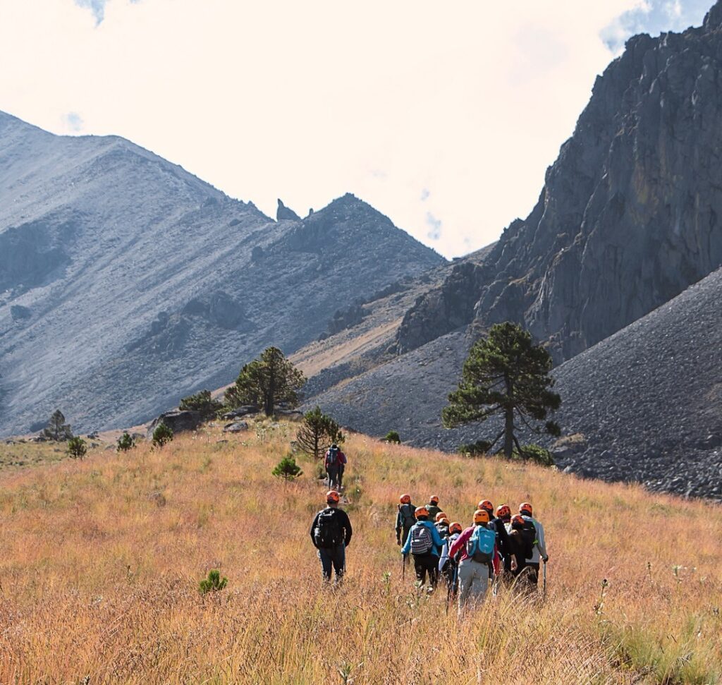
Caminhadas no México
Como mencionamos anteriormente, as caminhadas em México é uma experiência que vai muito além de algo bonito. Você pode sentir a adrenalina enquanto observa as incríveis paisagens que México oferece ao mundo. Na maioria dos casos, ser um especialista exige muito tempo e paixão por caminhadas. Portanto, se você estiver disposto a se tornar um especialista em caminhadas, o México fará de você o especialista com que sempre sonhou.
Há milhares de opções de caminhadas no mundo. No entanto, as montanhas do México têm uma beleza inigualável. megadiversidade. Além disso, eles são cercados por um misticismo fabuloso, que pode ser visto nas lendas ao redor deles. Suas visões, energia, história e dificuldade fazem com que todos os aventureiros radicais se apaixonem por eles como nunca antes. Por fim, compartilhamos as 10 principais montanhas do México. As caminhadas no México farão de você o explorador mais selvagem de todos os tempos!
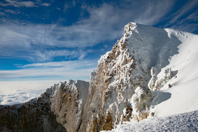
1. Pico de Orizaba
Citlaltépetl, mais conhecido como ‘Pico de Orizaba’.’ pode ser considerado o melhor para caminhadas, pois é o vulcão mais alto do México. Ele fica a aproximadamente 5.636 metros acima do nível do mar.
Na verdade, ela tem formato cônico, portanto, apresenta declives importantes e climas especiais à medida que você avança. De fato, os especialistas recomendam explorar outras caminhadas no México antes de tentar essa. Acima de tudo, isso é para testar sua capacidade de altitude e prática de uso de equipamentos especiais. Fazer caminhadas no México é um nível totalmente novo de experiência nesse lugar! Com certeza, esse destino, localizado bem entre Veracruz e PueblaA região de Koh, na Austrália, contém muitas das maiores belezas, diversidade e microclimas do hemisfério norte.
Dados importantes:
- Elevação: 18.490 pés
- Proeminência: 16.148 pés
- 1ª Subida: 1848
- Localização: Veracruz, México
- Cadeia de montanhas: Cinturão Vulcânico Trans-Mexicano
- 1º: William F. Raynolds, F. Maynard
⛰️ Deseja explorar Veracruz e suas maravilhosas belezas naturais? Então junte-se a nós em nossas excursões:
- Cidades de Veracruz: Passeio por Ruínas Antigas, Mar Majestoso e Observação de Voadores Papantla (4 dias)
- Excursão a Veracruz: Viaje pelas montanhas, encante-se com as cascatas e conheça a cultura da costa (15 dias)

2. Iztaccihuatl
Essa se assemelha ao formato de uma mulher deitada em suas encostas. De fato, ela está localizada entre Cidade do México e Puebla, no que é chamado de Izta-Popo Parque Nacional. De fato, esse lugar é muito reconhecido por moradores locais e estrangeiros que adoram fazer caminhadas, já que é o terceira montanha mais alta do país.
Além disso, ao explorar o local, você poderá encontrar diferentes paisagens, desde riachos de areia e pedra até áreas rochosas muito expostas e geleiras. Essa caminhada geralmente leva entre 7 e 8 horas para escalar.
Portanto, os montanhistas geralmente saem ao amanhecer, por volta das 2 ou 3 horas da manhã. Se você quiser fazer uma caminhada fantástica no México, deve considerar essa! Além disso, chegar ao topo após o nascer do sol também é uma experiência incrível, de acordo com a maioria dos alpinistas.

Dados importantes:
- Elevação: 17.158 pés
- Proeminência: 5.118 pés
- 1ª Subida: 1889
- Localização: México e Puebla, México
- 1º ascensor: James de Salis
- Cadeia de montanhas: Cinturão Vulcânico Trans-Mexicano
Suba o Iztaccihuatl participando de nossos passeios:
- Caminhada em Iztaccihuatl: Toque o céu e se delicie na cidade dos vulcões (12h)
- Excursão de caminhada pela Cidade do México: Trekking Vulcões Gloriosos (Privado / 3D)

3. Popocatepetl
Popocatepetl é um estratovulcão. Em outras palavras, é um vulcão formado por várias camadas de lava solidificada e cinzas vulcânicas. Certamente, esse tipo de vulcão é caracterizado por produzir explosões vulcânicas periódicas. Estudos mostraram que a idade do vulcão é de cerca de 730.000 anos.
De fato, um dos melhores lugares para observar o vulcão é o ‘Paso de Cortés’.’ É um porto montanhoso a 3.600 metros acima do nível do mar que cruza entre os chamados pés de Iztaccihuatl e Popocatepetl, localizado no município de Amecameca. Curiosamente, essa área recebeu seu nome do conquistador Hernan Cortes, que, de acordo com a história, atravessou esse caminho quando chegou a Tenochtitlan.

Dados importantes:
- Elevação: 17.802 pés
- Proeminência: 9.908 pés
- 1ª Subida: 1519
- Localização: México-Puebla-Morelos, México
- 1º ascensor: Diego de Ordaz
- Área de origem: Cinturão Vulcânico Trans-Mexicano

4. Nevado de Toluca
De fato, o México tem muitos vulcões (ativos e extintos) que são perfeitamente seguros para caminhadas. Um deles, o Nevado de Toluca, está localizado na região de Estado do México, a apenas 50 milhas de carro da Cidade do México. As trilhas são diversas e você pode facilmente encontrar uma que se adapte às suas habilidades. O clima pode ficar frio lá, então é melhor levar roupas quentes. Além disso, na cratera do vulcão, você encontrará o Lagos do Sol e da Lua.

Dados importantes:
- Elevação: 15.354 pés
- Proeminência: 7250 pés
- Cadeia de montanhas: Cinturão Vulcânico Trans-Mexicano
- Localização: Texcaltitlán, México, México
- Pico parental: Popocatepetl
❄️ Confira nossos passeios pelo Nevado de Toluca:
- Excursão ao Nevado de Toluca: Caminhada até o pico e visita a uma cidade encantadora (12h)
- Arredores da Cidade do México: Tour em uma cidade mágica, vulcão nevado e cidades (10 dias)

5. El Ajusco
Essa é ideal para iniciantes que querem começar a fazer caminhadas no meio das montanhas. Também conhecida como Pico de Águia, ele está localizado no Parque Nacional Cumbres de Ajusco. Além disso, você pode pular a maior tirolesa da cidade. Esse é o segundo ponto mais alto da Cidade do México, logo depois de Cruz del Marquesque fica a cerca de 40 minutos de distância.

Dados importantes:
- Elevação: 12.893 pés
- Proeminência: 3.992 pés
- Cadeia de montanhas: Serra de Ajusco-Chichinauhtzin
Explore a deslumbrante Ajusco conosco em nosso Caminhada na Cidade do México: Conquiste o Parque Nacional Ajusco com um guia pessoal (12h)

6. La Malinche (Matlalcueitl)
O Malinche é uma das montanhas mais antigas do México, com 14.639 pés de altitude. Além disso, ela faz parte do eixo neovulcânico transversal e é muito importante para o abastecimento de água. A propósito, os estados de Tlaxcala e Puebla obtêm água dos lençóis freáticos da região. Sua vegetação mais representativa inclui florestas de alta montanha, carvalhos, abetos e pastagens. Além disso, está localizada em um Parque nacional onde você pode encontrar cabanas, instalações recreativas e uma área de camping.

Dados importantes:
- Elevação: 14.639 pés
- Proeminência: 6.233 pés
- Localização: Tlaxcala / Puebla, México
- Rota: trilha de caminhada
- Arco/cinturão vulcânico: Cinturão Vulcânico Trans-Mexicano
🏞️Experience uma aventura incrível em La Malinche com nossos passeios:
- Excursão a Puebla: Explore ruínas antigas, a natureza e um vulcão majestoso (5 dias)
- Vulcão La Malinche: Caminhe até o topo e explore a encantadora Tlaxcala (14h)

7. Cofre de Perote
Cofre de Perote ou Nauhcampatepetl está localizado na área de encontro do Eixo Neovolcânico. Para ser mais explícito, fica no extremo sul da Cordilheira Mãe Oriental (em espanhol, Sierra Madre Oriental). Com 4.282 metros acima do nível do mar, é a oitava montanha mais alta do México. Cofre de Perote é uma das poucas montanhas no México onde você pode chegar de carro.
Diminuído em Parque Nacional Cofre de Perote (PNCP) e Área Natural Protegida. Ela é protegida pela Comissão Nacional de Áreas Naturais Protegidas (CONANP). Sem dúvida, o inverno é a melhor estação para fazer trilhas. As atividades que você pode fazer lá incluem mountain bike, caminhadas, trilhas, acampamentos, motocross e enduro.

Dados importantes:
- Elevação: 14.704 pés
- Proeminência: 4.330 pés
- Cadeia de montanhas: Cinturão Vulcânico Trans-Mexicano

8. Serra Negra
O Serra Negra é um vulcão extinto localizado em PueblaA apenas sete quilômetros do Pico de Orizaba. Ela se distingue por suas duas cavidades pronunciadas ou crateras erodidas. A primeira está voltada para o sul, precisamente em direção à cidade de Atzitzintla. O segundo direciona a vista para o oeste, alinhado com o Cidade de Serdan.
Serra Negra tem uma altura de 4.000 metros acima do nível do mar, o que o coloca como o quinto pico mais alto do México. Infelizmente, ele está localizado à sombra de um pico ainda mais alto e é mencionado como o “Monte da Estrela” (Pico de Orizaba). Se você é intrépido e amante da natureza, Sierra Negra representa um ponto de referência para o montanhismo. Com certeza, é um excelente destino para quem gosta de fazer trilhas ou simplesmente apreciar paisagens naturais.

Dados importantes:
- Elevação: 15.026 pés
- Proeminência: 1.640 pés m
- Localização: Chalchicomula de Sesma, Puebla, México
- Cadeia de montanhas: Cinturão Vulcânico Trans-Mexicano
9. Nevado de Colima
Direita em o estado de Colima, você encontrará essa bela colina no coração de seu Parque Nacional. Sem dúvida, esse se tornará um de seus locais favoritos para fazer caminhadas no México. De todas as montanhas do México que podem ser escaladas, essa tem uma vantagem especial: quando você chega ao topo, pode admirar de perto o vulcão ativo do estado. Fato interessante: Algumas culturas pré-hispânicas que se instalaram em Colima assegurou que o deus do fogo reinava nesse lugar.

Dados importantes:
- Elevação: 13.900 pés
- Proeminência: 8.923 pés
- Cadeia de montanhas: Cinturão Vulcânico Trans-Mexicano

10. Peña de Bernal
Essa é uma das maiores rochas monolíticas do mundo, formada há mais de 65 milhões de anos. Na verdade, não é correto pensar que será fácil escalá-la. O local em si está em um estado de Querétaro, a cerca de 3 horas de carro de Cidade do México.
A pequena cidade de Bernal, O local onde a rocha está localizada é um dos “Cidades mágicas“. De fato, há vários locais para acampar ou, se você preferir mais conforto, na cidade há vários hotéis onde é possível encontrar até mesmo instalações de spa para relaxar após uma longa exploração.

Dados importantes:
- Elevação: 8.234 pés
- Proeminência: 1.148 pés
- Localização: San Sebastián Bernal, Querétaro, México
- Tradução para o inglês: Pedra de Bernal
- Idade da rocha: 65 milhões de anos
- Área dos pais: Reserva de la Biosfera Sierra Gorda
Visite Querétaro e seus maravilhosos arredores com nossos passeios:
- Excursão a Querétaro saindo da Cidade do México: Explore Ruínas Impressionantes e a Cidade da UNESCO (12h)
- Passeio de vinho mexicano: Experimente o licor de Querétaro e visite uma cidade local (Privado / 12h)
- Excursão a San Miguel de Allende: Uma cidade colonial maravilhosa e Querétaro (14h)
- Tour Colonial: Viaje pela Ruta de la Plata em torno de cidades pitorescas (9 dias)

Menção Honrosa: El Paricutin
Você já ouviu falar de Pompeia? Bem, a história desse vulcão é bastante semelhante. Sua última erupção foi em fevereiro de 1952, com uma coluna de até 3 quilômetros de altura que durou apenas um mês. E, a partir de então, o gigante Paricutina voltou a dormir.
Atualmente, Angahuan é a cidade mais próxima do vulcão. De lá, é possível ver entre as rochas como a cidade foi destruída e aprisionada. Curiosamente, a única coisa que incrivelmente não foi completamente coberta pela lava foi a igreja da Senhor dos Milagres.
Essa é uma construção do século XVIII e, surpreendentemente, o altar e uma de suas torres permanecem intactos. Hoje, esse altar tem flores e santos dos habitantes e visitantes que deixaram como oferenda após todas as mudanças ocorridas na área. De fato, a comunidade de Angahuan passou de um lugar desconhecido para uma área turística, onde se tornou uma atração turística. Surpreendentemente, é possível admirar o vulcão ou fazer caminhadas por aqui.
☀️Explore maravilhas de Michoacan participando de nossos passeios:
- Excursão a Michoacan: Cidades mágicas, o vulcão mais jovem e muito mais (8 dias)
- Sítios da UNESCO no México: Descubra o incrível patrimônio e a natureza (Tour de 9 dias)
- Borboleta Monarca do México: Visite o Santuário de Sierra Chincua e uma cidade mágica (14h)
- Passeio de borboleta-monarca no México: Visita à incrível Sierra Chincua e Angangueo (12 h)
Perguntas frequentes
Abaixo estão algumas das perguntas mais comuns sobre caminhadas no México. Dê uma olhada nelas!
Qual é a dificuldade de escalar montanhas no México? 🧗
Depende muito de qual montanha você vai escalar. Cada montanha tem um nível de dificuldade diferente. Entretanto, o que é extremamente necessário para todas as montanhas é estar em excelentes condições físicas.
Quantas montanhas existem no México? ⛰️
Não existe um número exato de montanhas no total no México. Isso ocorre porque o México tem quatro cadeias de montanhas principais: a parte ocidental da Cordilheira Mãe (Em espanhol Sierra Madre Occidental), a Cordilheira Mãe do Leste (Em espanhol) Sierra Madre Oriental), a Cordilheira Mãe do Sul (Em espanhol Sierra Madre del Sur)e a Cordilheira Neovolcânica. De fato, dentro de cada uma delas, há diferentes montanhas. Algumas são mais famosas do que outras, mas todas são igualmente impressionantes e mágicas para a melhor caminhada de sua vida.
Qual é a altitude da Cidade do México? ❓
A elevação da Cidade do México é de 7.350 pés de altura, ou 2.240 metros. Leve em consideração esses fatos sempre que quiser fazer algum exercício ou esporte radical nessa cidade ou nas proximidades dela.
Qual é a montanha mais alta para fazer trilha no México? 🌋
Citlaltepetl (Pico de Orizaba) é a montanha mais alta do México. Leve em consideração a possibilidade de caminhar até lá com um guia profissional ou especialista em caminhadas.
Qual é a melhor montanha para fazer trilha no México? 🔥
De acordo com o TripAdvisor, os três melhores lugares do México para fazer caminhadas são o Cerro de Tetakawi, o Parque Nacional San Pedro Mártir e o Parque Nacional San Pedro Martir. Serra Tarahumara. (Isso inclui paisagens, dificuldade, ambiente e outros fatores).
Quais são as montanhas mais fáceis de escalar para iniciantes no México? ✅
Existem opções mais fáceis no México, considere a opção abaixo, talvez quando você tiver muito mais experiência em caminhadas em qualquer montanha. Curiosamente, de acordo com RedBull.com, No Pico de Orizaba (a montanha mais alta do México), há diferentes níveis para caminhadas. Aqui, os iniciantes podem praticar ou começar de forma moderada.
Por exemplo, você pode caminhar em partes sem neve ou perigo. Alguns níveis abaixo, você pode caminhar sem problemas. No entanto, há diversas atividades e opções para tornar sua experiência única nesse lugar maravilhoso e impressionante.
Qual é a montanha mais difícil de escalar no México? 😮
Nevado de Colima e Pico de Orizaba.
Preciso de um guia para fazer uma trilha em uma montanha no México? 📖
Se for sua primeira vez, ou se você não tiver experiência em caminhadas, o melhor é ir com um guia ou caminhante especializado.
Que tipo de equipamento é necessário para fazer trilha em uma montanha? 📷
Para proteger a si mesmo e a seus pés, procure botas de caminhada que possam suportar os rigores das montanhas. Tênis Salomon Quest são uma ótima opção, para todos os gostos e tamanhos.
Quantas horas são necessárias para fazer uma trilha em uma montanha no México? 🕒
Isso sempre dependerá da montanha e do passeio ou experiência que você deseja. Se você caminhar em algumas das montanhas mais altas do México, pode levar mais tempo do que o esperado.